NATURAL DISASTER
On 28th September, 2018 (Friday) a tsunami and an earthquake approached the Indonesian Coast. The earthquake occurred as a result of strike-slip faulting at shallow depths within the interior of the Molucca Sea microplate (part of the broader Sunda tectonic plate) and its magnitude was 7.5 (Richter scale) (USGS, 2018) (Table 1).
Table 1 – Earthquake characteristics according to the United States Geological Survey.
| Description | Strike-slip fault (slip over a larger fault area) |
| Size (length x width) | 120 x 20 km |
| Modeling dimensions | ~150 x 30 km |
| Rupture length (including surface rupture through the city of Palu) | ~150 km |
| Magnitude (Richter scale) | 7.5 M |
CRITICAL ANALYSIS
Most of the information available on the internet that has been spread by the media tell that the tsunami was provoked through this 7.5M earthquake. However, this type of fault (strike-slip fault) wouldn’t originate a tsunami due to its characteristics (Table 1) and its location (Figure 1). Usually, tsunamis are not originated by land faults as this one (Figure 1). What caused this tsunami may have another source and epicenter.
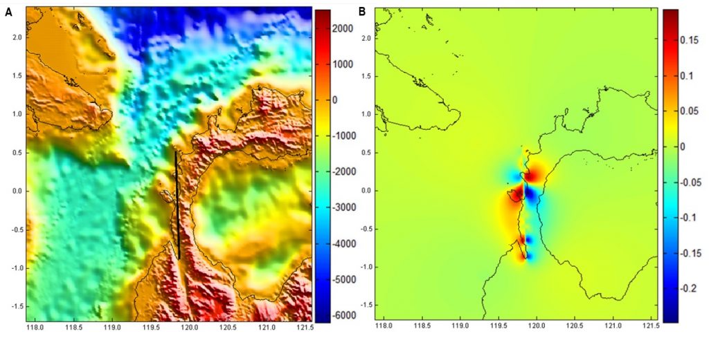
Figure 1 – Indonesia bathimetry (scale in meters), coastline (black curvy line), fault (straight black line) (A) and its (okada) vertical deformation in meters (B). The fault occured in Indonesia on 28th September, 2018. The x axis represents the latitude and the y axis represents the longitude. Images produced using the Mirone software.
“Scientists have been left stunned by the size and speed of the deadly tsunami, which is estimated to have travelled at up to 800 Km/h.” (Leith Huffadine, 2018).
“This earthquake, I think it is up for a lot of debate about what the cause of the tsunami was.” (Unknown, 2018 in Leith Huffadine, 2018).
“There’s still a lot of work that’s going to need to be done before we can say with any certainty what the cause of the tsunami was.” (John Ristau, 2018 in Leith Huffadine, 2018).
CONSEQUENCES
General Consequences (Fishing Point of View)
Communities depending on fisheries can suffer severe consequences when natural disasters approach their territories. That is what happened with the Indonesia’s tsunami and earthquake. An example of that is the destruction of the remote fishing area of the town of Donggala. Some satellite images that appear in the media show parts of the city completely submerged in water with widespread damage to buildings (Figure 2).
Along with the destruction and deaths, people that were dependente on fishing activities need a life rebuilding. Fisheries are a valuable activity to communities and are totally dependente on the life stock, aquaculture and economy. It is part of societies and cultures. When one of these pillars fall, all of them became unstable.
Mitigation and loss assessments are required to rebuild the pillars.
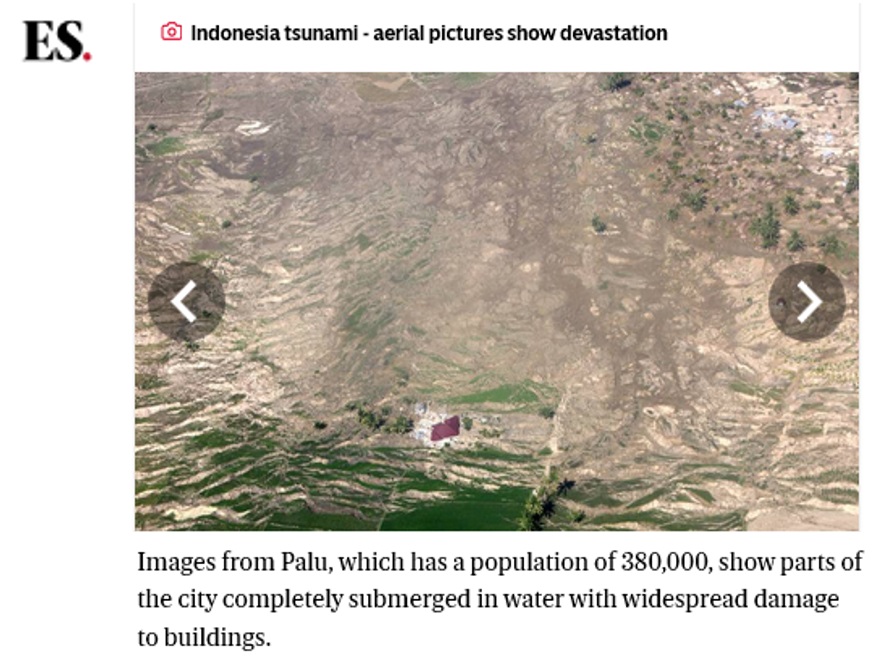
Figure 2 – Evening Standard news picture of Donggala city completed submerged. The title of the article is “Indonesia tsunami: Fears remote fishing area Donggala has been wiped off the map after devastating earthquake” (Patrick Grafton-Green, October 2nd , 2018).
DISASTER RISK MANAGEMENT, PREPARENESS AND MITIGATION
Disaster risk management processes are required to decrease the adverse impacts or hazards and possibly disasters, such as the occurred Indonesia earthquake and tsunami. It is a systematic process that uses administrative directives and policies (Figure 3) and it should be take in consideration for the safety of the communities.
RISK = PROBABILITY OF A HAZARD X CONSEQUENCE
(Helm, 1996)
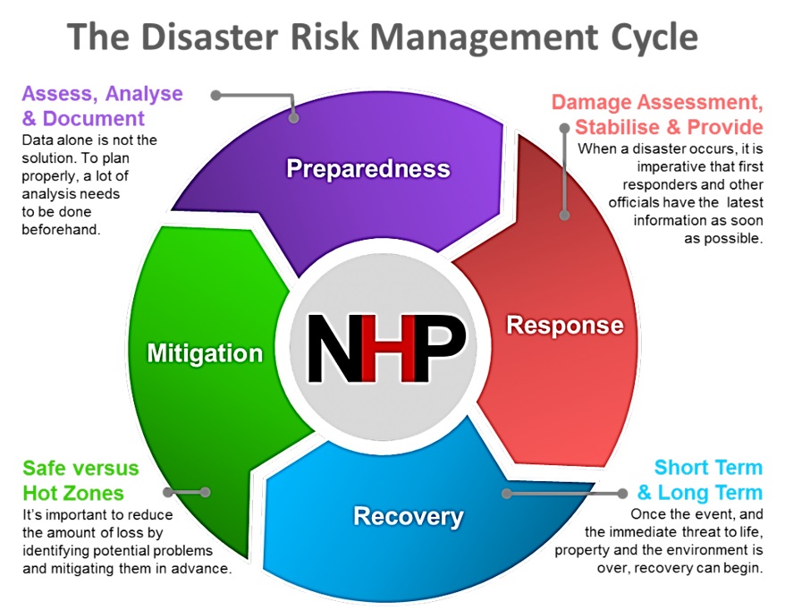
Figure 3 – A simple disaster risk management cycle in which the preparedness, response, recovery and mitigation is expressed by purple, red, blue and green respectively. Each step of the disaster risk management cycle is described with its respective colors subtitled. Source: Natural Hazards Partnership.
REFERENCES
Grafton-Green, Patrick (September 29th, 2018). Indonesia tsunami: Fears remote fishing area Donggala has been wiped off the map after devastating earthquake: https://www.standard.co.uk/news/world/indonesia-tsunami-fears-remote-fishing-area-donggala-has-been-wiped-off-the-map-after-devastating-a3949176.html;
Helm, Patrick (1996). Integrated risk management for natural and technological disasters. Tephra, 15(1), 4-13;
Huffadine, Leith (October 2nd ,2018). What caused Indonesia’s devastating monster tsunami? Stuff.: https://www.stuff.co.nz/world/asia/107522981/what-caused-indonesias-devastating-monster-tsunami;
Luis, Joaquim Manuel (Acessed on October 19th, 2018). Mirone: Compute seismic elastic deformation: http://w3.ualg.pt/%7Ejluis/mirone/howtos/Compute_seismic_elastic_deformation.pdf;
NHP – Natural Hazards Partnership (Acessed on October 19th, 2018) .Our role within the Disaster Risk Management Cycle: http://www.naturalhazardspartnership.org.uk/about-us/;
USGS – science for a changing world (Acessed on September 28th, 2018). M 7.5 – 78km N of Palu, Indonesia: https://earthquake.usgs.gov/earthquakes/eventpage/us1000h3p4/executive.
PICTURE
Maps of the World (Acessed on October 19th, 2018). Maps of Indonesia: http://www.maps-of-the-world.net/maps-of-asia/maps-of-indonesia/.