Marine Resources
To monitor marine resources it’s necessary to stablish parameters that are the most significant to have a complete characterization. Those parameters are: Temperature, Sea-level, Currents, Chlorophyll-a, Dissolved Oxygen and Nutrients. To measure it we can resort to several data bases such as the Copernicus Marine Environment Monitoring Service (CMEMS) that has a space component and an in situ component to collect data. Ergo, it is possible to obtain “long time-series of in-situ (physical and biochemical) and remote-sensing (ocean colour and SST) products, reanalysis of hydrodynamic and ecosystem models and analysis and forecasts of hydrodynamic and ecosystem models” (CMEMS, 2017) as research products. So, the protection, preservation and the sustainable management of marine resources can be provided, in particular for aquaculture and fishery regional organizations or research. “Any ecosystem-based approach to fish stock management also benefits from CMEMS core information.” (CMEMS, 2017).
Because we can’t never work alone to solve marine resources issues, another organizations are coupled like FAO (Food and Agriculture Organization of the United Nations), ICES (International Council for the Exploitation of the Sea) and National Fishery Agencies.
Coastal Marine Environment
The parameters used to characterize coastal marine environments are the same as in marine resources, but adding the PAR (light). The originated products are also similar. In this way, monitoring services can be provided by organizations at European and National Levels.
The organizations coupled are: EEA (European Environment Agency), HELCOM (Helsinki Commission), OSPAR (OSLO-PARIS Commissions), UNEP/MAP (United Nations’ Environment Programme (UNEP)/Mediterranean Action Plan (MAP)) and National environmental agencies.
Other Materials and Methods
We can use several other data bases to monitor oceans. Each one has different calibrations and precisions, but if we combine them all (Figure 1) it is possible to write a complete scientific review article about a precise localization. Those are the other data materials and data methods that can be used:
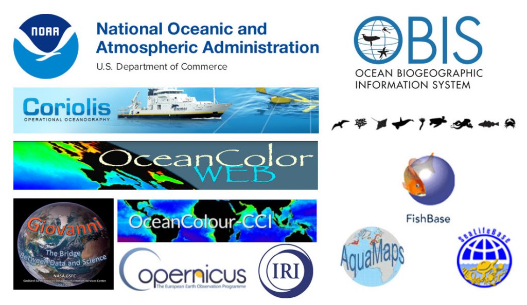
Figure 1. Data bases to monitor oceans.
- AquaMaps
- FishBase
- Giovanni
- IRI – International Research Institute for Climate and Society
- NOAA – National Oceanic and Atmospheric AdministrationOBIS – Ocean Biogeographic Information SystemCoreolis Operation Oceanography
- Ocean Color Web
- SeaLifeBase
Webgraphy:
- http://www.aquamaps.org/
- http://www.fishbase.org/search.php
- https://giovanni.gsfc.nasa.gov/giovanni/
- http://iridl.ldeo.columbia.edu/
- http://marine.copernicus.eu…
- http://www.noaa.gov/
- https://oceancolor.gsfc.nasa.gov/
- http://www.sealifebase.org/